TABLE OF CONTENTS. Executive Summary. 1. I. Introduction. 3. II. Overview and Purpose of the Miami-Dade. Urban Development Boundary.
578 KB – 69 Pages
PAGE – 2 ============
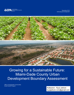
II PROJECT CONTACTS EPA Contact: Kevin Nelson Development, Community and Environment Division (now the Office of Sustainable Communities) U.S. Environmental Protection Agency 1200 Pennsylvania Avenue, NW (MC 1807T) Washington, DC 20460 Tel (202) 566-2835 Nelson.kevin@epa.gov ICF Contact: Amy Doll ICF International 9300 Lee Highway Fairfax, VA 22031 Tel (703) 934-3244 ADoll@icfi.com Miami-Dade County Contact: Subrata Basu Miami-Dade County Department of Planning and Zoning 111 NW First Street, 11 th Floor Miami, FL 33128 Tel (305) 375-2557 basus@miamidade.gov Consultant Team: Bill Fulton Design, Community and Environment 1625 Shattuck Avenue Suite 300 Berkeley, CA 94709 Tel (510) 848-3815 BillF@dceplanning.com Tim Chapin Florida State University 3733 Esplanade Way Tallahassee, FL 32311 Tel (850) 644-8515 tchapin@fsu.edu Cover Images: (Miami-Dade County Urban Development Boundary near Everglades National Park, agricultural land outside the boundary) Source: Subrata Basu
PAGE – 3 ============
III TABLE OF CONTENTS Executive Summary 1 I. Introduction 3 II. Overview and Purpose of the Miami-Dade Urban Development Boundary 5 III. Current Status and Issues 10 IV. Future Options 12 V. Outside-the-Line Policy 17 VI. Inside-the-Line Policy 22 VII. Environmental Results 26 VIII. Next Steps 28 IX. Conclusions 30 Appendix A EPA™s Smart Growth Implementation Assistance Program 31 Appendix B Development Boundary Case Studies Boulder, Colorado Portland, Oregon San Diego, California Sarasota, Florida 33
PAGE – 4 ============
1 EXECUTIVE SUMMARY Miami-Dade County, Florida, like many communities around the country, faces development pressures and struggles to manage its growth. Unlike many other communities, Miami-Dade County is bounded by an ocean and two national parksŠplaces that the community wishes to preserve. Decades ago, to address unchecked growth and development, county officials decided to institute growth management strategies. Now that these policies have been in place for many years, Miami-Dade County requested the U.S. Environmental Protection Agency™s (EPA™s) assistance in reviewing the policies and guidelines of its Urban Development Boundary (UDB), a key tool in the county™s growth management strategy. The UDB dates from the 1970s and was incorporated into the county™s Comprehensive Development Master Plan in 1983. The UDB shoul d contain a 10 plus 5-year supply of land for residential development. Proposed changes to the UDB require a two-thirds vote from the County Commissioners. In 2008, the UDB contained 269,000 acres (420 square miles), of which approximately six percent was undeveloped. 1 Very little land has been added to the UDB in the last 20 years. Developers and citizens™ groups have both e xpressed discontent with the process for amending the UDB, which permits landowners and developers to apply for amendments every two years. Under question is whether this current process of amending the boundary manages growth outside the boundary effectively while encourag ing infill development in side the boundary. For the purpose of this document, the term fiinfillfl includes vacant land development and redevelopment projects. The EPA team and the county held a policy wo rkshop in Miami on October 14-16, 2009, to discuss ideas for amending the UDB and to provide options for county officials to consider. Among the issues identified at the workshop and discussed in this report are: The remaining undeveloped land inside the UDB may or may not be sufficient to accommodate 15 years of residential developm ent, depending on how the infill policies are implemented. Low-density residential development on 5- acre per unit zoning outside the UBD. Agricultural land outside the UDB is dwindling. Combined with changing farm economics and competition from other countri es, this gradual loss of farmland is threatening the ficritical massfl required to sustain agricultural operations. Deciding where the boundary might ultimately be located was beyond the EPA team™s charge. Instead, this report focuses on several related questions, including: What process could be used to amend the UDB? 1 Miami-Dade County Department of Planning and Zoning , Urban Development Boundary Amendments Adopted from 1976 through 2008. November 25, 2008.
PAGE – 5 ============
2 What methodology could be used to determine land supply? What policies could be in place inside th e boundary to encourage infill development? What policies could be in place outside th e boundary to encourage land conservation? To answer these questions, the EPA consultant team met with a variety of stakeholders, including elected officials, developers, citizens™ groups, property owners, and environmental groups. In these meetings, the team learned what works in the current process for amending the UBD and what could be improved. The team also used stak eholder input to develop options that could help the county balance growth management strategies focused outside the line and those geared for inside. The majority of the report addresses the first two questions. Encouraging infill and the promotion of land conservation are discussed throughout the report with specific examples from other communities. Outside-the-Line Policy Simply creating the UDB does not necessarily con serve land, especially because of the 5-acre zoning outside the line. This report presents sever al options the county could consider for the ultimate disposition of land outside the UDB, including: A master plan for the conservation and development of the area currently outside the boundary. A formal phasing plan using the Urban Expansion area mechanism. Better-coordinated land acquisition programs. Larger and more comprehensive landowner compensation programs. Policies that ensure more land remains in ag ricultural use instead of acting as a reserve for future development. Inside-the-Line Policy Protecting land outside the UDB requires progressive policies inside the line. Many of these policies are already in place, but the county want s to promote more infill development. Possible steps include: Targeting infrastructure investments to infill areas. Ensuring that infill policies reflect market realities and promote redevelopment. Promoting horizontal mixed use as well as vertical mixed use. Promoting a variety of housing types, sizes, and styles. Promoting and enabling higher-density empl oyment centers near transit stations. The next steps for local decision-makers are to review the options provi ded here and determine how to address the management of the line. Th is assistance was not meant to help Miami-Dade County decide where to place the line, but rath er to analyze current practices and point out options that could be considered when the c ounty revises the process for managing the UDB. It will be up to elected officials and staff to determ ine how, if at all, to change the process for managing the UDB and policies that govern development inside and outside the line.
PAGE – 6 ============
I. INMiami-D aaround th county c oissues andexisting indevelopmProtectionanalyzin g(See Appe Managingencouragewhat is mcommuni tgrowth boboundary ,respect to protect itsinfrastruct The UDBEvergladethe boun dthe years, requests fbe impro v Figure 1: Subrata BInfill opportunBasu) nities exist aroound Miami, eespecially he r re along the MMiaNTRODUCTIOade County, Fe country. W iontains many rd pressures a snfrastructure ment more sus tn Agency (E Pg the policies aendix A for mg growth is a fe developme nmeant by appr oties, includin goundary. For M, but rather t o their values. s unique natu rture, transit, aB is used pri mes National Padary has been the managemfrom develop eved. ON Florida faces mith highly ur bresources ands it struggles tand investmetainable over PA) Smart Groand proceduremore informa tfunction of v ant in logical anopriate is def ig Miami-Da dMiami-Dade o question if t hIn broad ter mral environmeand other am earily to keep ark. Because moved to ac cment of the UDers or county many of the sbanized areas ,d assets, but i tto balance co nents. Recognizthe long ter mowth Imple me for managintion on the SGalues Πwhat and appropriatined through cde County, tr yCounty, the qhe current proms, Miami-D aent, and encouenities. developmentthe county is commodate a pDB yielded instaff. The cousame growth , suburban st rt also must d entinued grow tzing the nee dm, county sta fmentation Assing its Urban DGIA program.a community te locations. Dcommunity i ny to systemati question was ocess for mo vade County wurage develo pt from spillin gan attractive pproved addincremental p aunty has sougissues that chrip developm eeal with a va rth with maki nd to be creati vff applied to t histance (SGI ADevelopmen t.) y seeks to presDetermining wnput and pub lically manag enot where to ving the line swants to keep pment in are ag toward highplace for newitions to the uarcels. These ght to explor ehallenge comment, and farmriety of devel ong the most ove and to mak he U.S. Envi rA) program f ot Boundary ( Userve and howwhat to prese lic policies. Se their growt hmove the gr ostill made senits agriculturaas with existi nhly sensitive l w jobs and re surbanized areawere added te how this sysmi River. (3 munities mland, the opment of its ke its land ronmental or help in UDB). w best to rve and Some h using a owth nse with al identity, ng lands like sidents, a. Through through stem could (Source:
PAGE – 8 ============
5 II. OVERVIEW AND PURPOSE OF THE MIAMI-DADE URBAN DEVELOPMENT BOUNDARY The UDB is an important tool in Miami-Dade County™s overall growth management system. Although it places geographical limits on certain types of urban development, it does not dictate the density or amount of development permitted either inside or outside the boundary. These issues are addressed through other policies in the county™s Comprehensive Development Master Plan (CDMP), primarily the future land use element and future land use map. The CDMP establishes the UDB as a central element of the county™s growth management system. The CDMP describes goals that the UDB is intended to achieve, including the efficient use of infrastructure and the promotion of compact de velopment. The UDB™s purpose, according to the CDMP, is to protect and preserve wetlands, prev ent low density development away from transit and neighborhood amenities and unc onnected development patterns, and plan for efficient expansion and improvement in infrastructure and public services. 3 While planning staff understand that the UDB has several goals and outco mes, the team™s review found that there is wide interpretation among stakeholders as to the goals and outcomes of the UDB, contributing to the lack of consensus among key decision-makers on the boundary™s location and the procedures for boundary expansion that led to the count y™s request for assistance on this project. The team™s discussions with a wide variety of st akeholders, including planning staff, elected officials, development industry interests, and self-identified fislow-growthfl advocates, suggested that they see the Miami-Dade UDB as having several different purposes including: To direct the efficient and cost-effective delivery of public services; To promote compact development and encourage transit ridership; and To preserve agricultural land and wetlands. While most stakeholders listed more than one of these goals as a reason the UDB exists, the fihighest priorityfl goal differed markedly by st akeholder. This lack of consensus on the UDB™s primary goal(s) has also led to substantial di sagreement on whether UDB expansion is desirable and, if so, where the UDB might be expanded. Different goals yield different implementation mechanisms and comprehensive plan policies. For example, the goal of efficient service deliver y might lead Miami-Dade County to expand the UDB to parcels immediately adjacent to areas curre ntly served by water and sewer, regardless of whether or not those places contain environmen tally sensitive land. By contrast, the goal of protecting agricultural land and land required fo r watershed protection might lead Miami-Dade County to place environmentally sensitive land or active agricultural land outside the UDB, even if these lands are located adjacent to existing water and sewer. Because the fundamental goals of the UDB are not clear, the county has struggled with how to implement a UDB strategy. Growth boundaries can play an important role in supporting planning and development goals, but their purpose needs to be clear. 3 Miami-Dade County. Comprehensive Development Master Plan . Amended April 2010.
PAGE – 9 ============
6 Very low -boundary ,-density resi d, while a varieunty policies sg land outsid esition. osed changesnd approval o ffrom the stat Urban Devel oMiami-Dade CB is required tol years™ supp lr UEAs, outsigrowth to ocdential devel oety of develo pseek to focus e the boundar ys to the UDB of proposed c he™s Departm eopment Bou nCounty) o contain a 15ly in reserve).ide the boun dccur. pment (5-acr pment types adevelopmen ty from any t yoccur throug hhanges by the ent of Commundary Map wi t5-year reside n. Miami-Dadedary, which a re minimum l oand densities t inside the boype of develo ph the plan a mCounty Co munity Affairs.th Boundary Cntial land sup pe County ma yre areas cons iot sizes) is p eare permittedoundary by enpment throu gmendment pro cmmission, as wChanges. ply (10 year sy also designaidered to be aermitted outs id inside the boncouraging i ngh land conse rcess, which rewell as reviews of supply pl uate fiUrban E xappropriate loide the oundary. nfill and rvation equires w and us 5 xpansion cations Other couprotectingand acqui Any prop review ancomment Figure 2: (Source: M The UDBadditionalAreas,fl o rfor future
PAGE – 10 ============
7 For many years, changes to the UDB resulted fro m staff analyses of land supply and demand, and planning staff developed many of the proposal s for UDB expansions. Two major review cycles, in 1983 and 1988, resulted in numerous site-speci fic UDB changes and were done in coordination with CDMP update cycles. The vast majority of other applications filed since 1975 have been driven by private applicants. Many of these privat e applications were filed and not adopted. In the last 15 years, this process has been driven more by private applicants than by staff analysis of needed supply. The county™s perceived result is that moving the line is driven by landowners wishing to amend the CDMP to bring more la nd inside the UDB. These proposed changes to the UDB are considered every other year. Under the current process, many residents are concerned that more and more land outside of the line will be subject to development pressures. When it was first created in 1975, the UDB c ontained approximately 233,000 acres (364 square miles). Since then, it has been increased by approximately 15 percent to 269,000 acres (420 square miles). (By contrast, a pproximately one million acres in Miami-Dade County lie outside the UDB, much of which is permanently preserve d.) Currently, about six percent of the land inside the boundary is undeveloped. 4 Most of this 36,000-acre expansion of the UDB occurred prior to 1990. Roughly half of this expansion occurred in 1988, following passage of the Growth Management Act, when about 16,000 acres of land were added to the UDB. Realizing the long term purpose of the act to restrict growth at the fringe, local officials expanded the boundary in the short term (in 1988) to provide a suitable amount of land available for development. In the past 21 years, only about 2,400 acres have been added, most of it the result of am endments in 2006, which added more than 1,400 acres. UDB expansions have slowed in recent years in part because changes to the UDB require approval by a supermajority of the Board of County Commissioners (meaning nine out of 13 commissioners must approve). Although proposed UDB expansions have often received a great deal of publicity, very few have been approved since the two-thirds rule was adopted in the 1990s.5 The two-thirds rule was put in place to raise the threshold of what could be considered an allowable expansion of the boundary. Making it more difficult to move the boundary ensured that each change was vetted with staff, elected officials, developers, and others. 4 Miami-Dade County Zoning Advisory Board Hearings for Properties Outside the Boundary, November 2008. 5 Miami-Dade County. Comprehensive Developm ent Master Plan, Miami-Dade County, 2008.
578 KB – 69 Pages